Drier and marginally colder than average - one notable cold spell gave the lowest temperature since Christmas Day 2010.
The month was fairly mixed with a few milder, wetter periods, but also with two cold spells. Of those cold spells, the first (8-16th) became very cold with the 11th recording the lowest temperature since Christmas Day 2010 and then also the first 'Ice Day' since March 2013. Then a cold snap at the month's end had a slight wintry feel.
The number of air and ground frosts was above average and likewise the number of days on which snowfall was recorded, but the reality was that any snow was minimal and short lived and did not have any notable impacts.
Overall the month was fairly average, but those frosts and the snowfall did at least make it feel like a winter's month, but unfortunately the worst day of the month was reserved for the 25th which saw heavy rainfall throughout the county.
During the month, there was two days of fog (2nd + 29th), one day with hail (7th), snow fell on 11 days and was laying on the ground (to a depth of at least 1 cm) on 2 days (29th and 30th).
MSLP of 1008.8 Mb was -3.3 Mb below the local average for December, mainly accounted for by the unsettled period from the 25th.
Overall a mean minimum of 0.31°c and a mean maximum of 6.34°c saw the temperature 0.1°c below the 1981-2010 average. It was the coldest since 2012 and of the nine now recorded, three have been colder and five warmer. The highest maximum temperature recorded was 11.6°c (6th), the lowest minimum -9.5°c (11th).
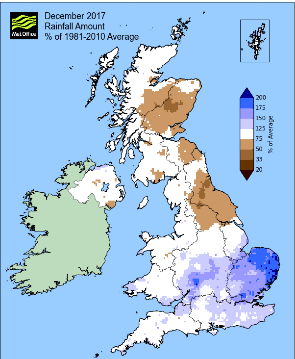
Rainfall of 106.1 mm (Crosby Ravensworth School 123.8 mm - Castlehowe Scar 124.7 mm - Reagill 97.0 mm) was 59% of average for 2007-16 and made it the wettest December since 2015. Of the eleven now recorded, five have been drier and five have been wetter.
Locally, rainfall percentages showed no particular pattern, falling either side of average, but yet again Seathwaite recorded a total that was well in excess of the average. The month had two wet days, 6th and jointly 24-25th with Seathwaite recording 160.8 mm on the 24th.
At the Met' Office site at Newton Rigg, 89.4 mm (85.1%) made it the wettest December since 2015 and in a series back to 1900, December has been drier in 51 years and wetter in 64 years (2yrs of missing data). A mean temperature of 3.3°c is the coldest since 2012 and in a series back to 1951, 24 have been colder and 42 have been warmer.
Figures from the Environment Agency’s rainfall sites were, (figure in brackets being the monthly average for 1961-90) ‘Data kindly provided by the Hydrometry and Telemetry team of the Environment Agency (Penrith)’:
Kirkby Thore 79.0 mm (71.7 mm)
Haresceugh Castle (Kirkoswald) 92.97 mm (85.1 mm)
Brothers Water 277.36 mm (304 mm) and
479.0 mm at Seathwaite Farm (Borrowdale - 382 mm [average for 1981-2010])
1st - 5th Despite never becoming fully established over the UK, High Pressure (HP) in the Atlantic was the dominant feature at the start of the month. The UK tended to sit on the eastern edge of the HP and this resulted in a cool NW'ly breeze, the days having little rain and some spells of brightness.
The month (and winter) started with a very slight dusting of snow on the ground and despite there been plenty of sun, it felt cold. Cloudier on the 2nd with spells of drizzle as a cold front to our north moved south and once that front had cleared south, the 3rd became an increasingly brighter day.
From the 4th the HP started to migrate east over France and this saw the airflow become SSW'ly which had the affect of lifting the day-time temperature to 8.8°c on both the 4-5th and it also remained dry.
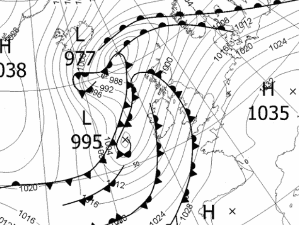
6th - 7th A deep area of low pressure (LP) had been developing in the Atlantic and which would track NE to the west of the UK and bring a spell of very heavy rain.
The rain and wind arrived mid afternoon of the 6th and would continue through the night into the 7th. At its heaviest either side of midnight, totalling 31.7 mm but without any great impact and it also saw the temperature peak at 11.6°c (52.9°f), the months highest temperature.
As the LP progressed NE it saw the HP re-establish itself in the Atlantic and with the position of the this and the LP, cold Arctic air was once again re-introduced - time for something much colder, starting with some hail and sleet later during the day on the 7th.
8th - 16th A notable cold spell with lowest temperatures since 2010
HP was sat out in the Atlantic and with the LP near Norway gradually weakening, the airflow was of Arctic origins, but with the pressure gradient gradually slackening. The tumbling temperatures became the main point as whilst we had, literally, the odd flake of snow, the snow reserved itself for further south and east of Cumbria.
The 8th saw the temperature peak at a then year's high of 1.3°c and was followed by a very cold night, falling to -4.4°c. The 9th managed to get as high as 2.2°c, but like the 8th it was a fine sunny day.
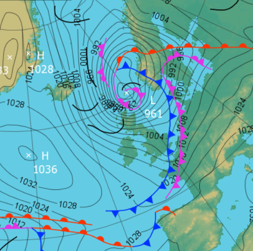
However, the cold now reached its zenith - despite areas of LP virtually surrounding the UK and bringing heavy snowfall to other counties, Cumbria sat within a slack pressure gradient and this allowed for clear skies. The 10th only managed a day-time maximum of 0.5°c and with those clear skies, the temperature very quickly tumbled after dark.
The 11th started with the lowest temperature since Christmas Day 2010, -9.5°c (14.9°f). It was cold and no amount of sunshine was going to warm this day up. At 0900 hrs the temperature was still -8.7°c and an 'Ice Day' followed, the first since 2013. A maximum temperature of -0.9°c (30.4°f) made Maulds Meaburn the third coldest location in the UK that day, beaten by two other sites in Cumbria, Brampton and Drumburgh with -1.5°c.
 1200 Hrs 11th - Cumbria sat in a slack pressure gradient that brought a very cold night and day
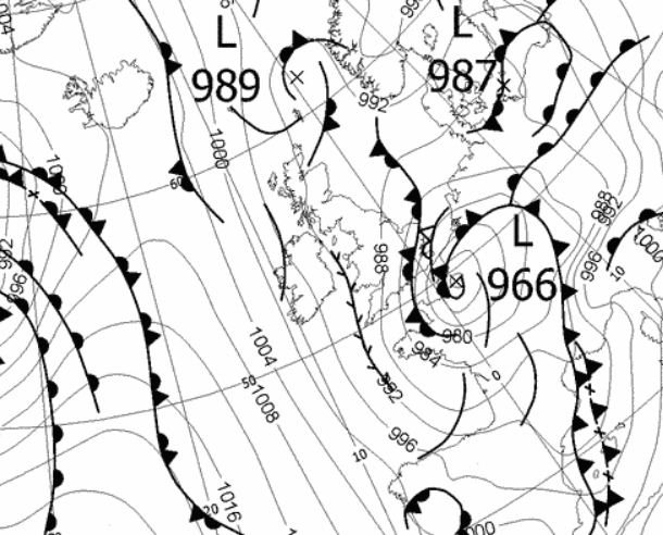
It remained cold with a wintry feel for the rest of the period, despite the slack pressure gradient giving way to a number of fronts from the Atlantic. With LP to our north those fronts brought some spells of either rain or sleet with daily totals typically 6-8 mm. The LP moved closer to the UK during the period, finally moving to our east and with HP once again building in the Atlantic, a cold Arctic airflow was once again drawn down.
The wintry feel continued, but with clear skies overnight into the 16th, the temperature fell away to -4.5°c and the day started with a snow shower and was followed by a cold and misty day. Clear skies brought a cold evening, but now this cold spell was drawing to an end and the run up to Christmas would herald in something much milder.
17th - 25th It then turned milder as HP in Biscay remained static throughout the period, drawing up a SSW'ly airflow. Whilst it became much milder, especially by night, the days became quite overcast and dull as we sat under a semi-permanent cloud cover, albeit, fortunately, there was very little rainfall during the period.
We still a few overnight frosts at first, but soon the night-time minima were above 5°c and later in the period above 6°c, reaching 8.0°c on the 24th. Whilst day-time maximums were typically 8-9°c, they did attain 11.3°c (52.3°f) on the 20th and then 10.3°c on the 23rd.
It was just the repetitive greyness of the days, which were frequently overcast and with the occasional bits of drizzle, but rainfall totals were negligible.
Come the 23rd the HP was marginally squeezed south and this allowed for an even stronger SW'ly flow over its top edge, giving a couple of very breezy days that had the effect of making it feel quite fresh, despite the temperature remaining on the mild side.
The period ended with the same set-up, HP to the south with a brisk SW'ly flow on its western edge, but now cold fronts associated to LP near Iceland approached the UK and the period finished with two wet days - weather wise, Christmas Day would be a write off!
Christmas Eve' saw spells of drizzle before rain arrived in the evening and then Christmas Day just saw that rain continue throughout and was accompanied by a strong wind that gusted to 49 Mph. The 24th had notched up 11.0 mm of rain and then the 25th had 14.5 mm with both days also been quite mild - a green Christmas this year.
26th - 31st It became cooler through to the end of the month with a slight wintry feel.
After a little rain during the morning, the 26th improved with the sun coming out in the afternoon and indeed the sun would also be prominent on the 27-28th. With LP having tracked from the SW across the southern half of the UK and exiting out into the North Sea, we once again returned to a N'ly flow of Arctic air. Subsequently the 27th would see temperatures struggle to 1.9°c and then clear skies overnight into the 28th resulted in a low of -4.6°c.
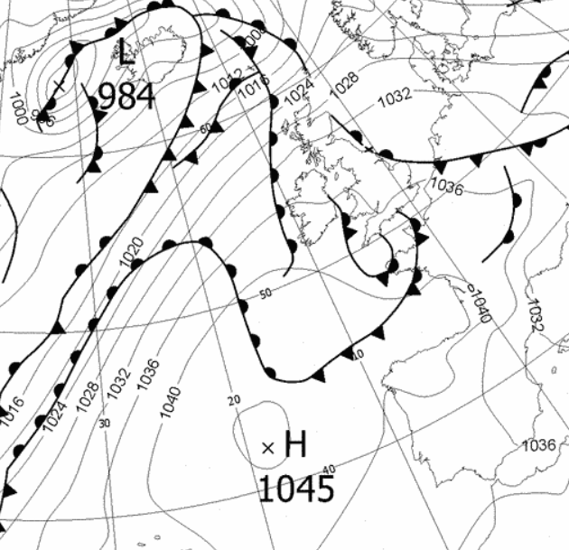
LP west of Eire then built late on the 28th and overnight into the 29th pushed an occluded front north across the UK. As this met the pool of cold air sat over the UK the outcome was snow, although altitude was still a factor in whether you got snow or rain. As it was, we got snow which stood at 2 cms deep (three quarters of an inch!) and with snow still falling during the morning. That snow petered out by lunch-time and the rest of the day was cloudy and getting warmer.
What followed came as a surprise - waking up on the 30th to a thin cover (1 cm) of snow. This time a warm front moved north across the UK during the night and whilst at first we had a little rain, this soon turned to snow.
With the temperature increasing that snow soon melted and then the month and year finished with another area of LP building west of Eire and bringing a spell of wind and rain.
 0600 Hrs 29th - Occluded front from the south that 'bumped' into the cold air and gave snow

Rainfall totalled 106.1 mm for the month, with rain recorded on 20 days of which 11 were 'Wet days' (1.0mm +).
The Mean Temperature for the month was 3.32°c -- The Mean Max' was 6.34°c -- The Mean Min' 0.31°c.
We had 18 Air Frosts in the month (year 63) -- Grass frosts totalled 21 (year 113).
The 1 foot soil temp ranged from a low of 2.8°c on the 13-14th to a high of 7.0°c on the 25-26th -- with a monthly mean of 4.6°c
The 1 meter soil temp ranged from a low of 6.2°c on the 19th-21st to a high of 8.0°c on the 1st -- with a monthly mean of 7.0°c
COMPARISONS:-
* December 2017 rainfall was 59% of the average for 2007 - 2016
* December 2017 was 0.52°c colder than the average for 2009 - 2016 and 0.1°c colder than the local long term average 1981-2010
* This makes the year of 2017 some 0.46°c warmer than the average for 2009-16 and with 86.7% of average rainfall for 2008-16
JANUARY 2010
FEBRUARY 2010
MARCH 2010
APRIL 2010
MAY 2010
JUNE 2010
JULY 2010
AUGUST 2010
SEPTEMBER 2010
OCTOBER 2010
NOVEMBER 2010
DECEMBER 2010
JANUARY 2011
FEBRUARY 2011
MARCH 2011
APRIL 2011
MAY 2011
JUNE 2011
JULY 2011
AUGUST 2011
SEPTEMBER 2011
OCTOBER 2011
NOVEMBER 2011
DECEMBER 2011
JANUARY 2012
FEBRUARY 2012
MARCH 2012
APRIL 2012
MAY 2012
JUNE 2012
JULY 2012
AUGUST 2012
SEPTEMBER 2012
OCTOBER 2012
NOVEMBER 2012
DECEMBER 2012
SUMMER 2012
REVIEW OF 2012
JANUARY 2013
FEBRUARY 2013
MARCH 2013
APRIL 2013
MAY 2013
JUNE 2013
JULY 2013
AUGUST 2013
SEPTEMBER 2013
OCTOBER 2013
NOVEMBER 2013
DECEMBER 2013
REVIEW OF 2013
JANUARY 2014
FEBRUARY 2014
MARCH 2014
APRIL 2014
MAY 2014
JUNE 2014
JULY 2014
AUGUST 2014
SEPTEMBER 2014
OCTOBER 2014
NOVEMBER 2014
DECEMBER 2014
WINTER 2014
REVIEW OF 2014
JANUARY 2015
FEBRUARY 2015
MARCH 2015
APRIL 2015
MAY 2015
JUNE 2015
JULY 2015
AUGUST 2015
SEPTEMBER 2015
OCTOBER 2015
NOVEMBER 2015
DECEMBER 2015
REVIEW OF 2015
JANUARY 2016
FEBRUARY 2016
MARCH 2016
APRIL 2016
MAY 2016
JUNE 2016
JULY 2016
AUGUST 2016
SEPTEMBER 2016
OCTOBER 2016
NOVEMBER 2016
DECEMBER 2016
REVIEW OF 2016
JANUARY 2017
FEBRUARY 2017
MARCH 2017
APRIL 2017
MAY 2017
JUNE 2017
JULY 2017
AUGUST 2017
SEPTEMBER 2017
OCTOBER 2017
NOVEMBER 2017
OTHER ARTICLES
The Oldest Inhabitant
An Inch Of Scotch Mist
© Darren Rogers 2010-17
Want to comment on this site? email